 |
|
||||||||||||||||||||||||||||||||||||||||||||||
|
South Africa : Planning |
Hier gehts zur
IntroSeite
Unten findet man nur lose Infos, die ich zur Planung benutzte
| Flug-Sites |
http://www.sahpa.co.za/sahpa/flying_sites.jsp?section=npg&title=FLYING%20SITES
There is now an interactive map
of all "official" flying sites in South Africa. Have a look! Below is a bit of
background information on the regions.
Let's see - I think SA can probably be split into 6 main flying areas.
|
|
|
||||||||||||||||||||||||||||||||||||||||||||||
Ich hab mir dort den Fresh Air SITE GUIDE - Flying in South Africa
( http://www.eternitypress.com)
gekauft. Das ist ratsam, wenn man vor hat,
auf eigene Faust ein paar Sites zu besuchen, und nicht nur nach
Wilderness und Porterville möchte. Er enthält unter anderem diese
praktischen ÜbersichtsKarten:
|
SITE NAME |
Best in |
GRADE |
Altitude |
|
Porterville |
W |
Basic |
800 |
|
Hermanus |
S |
Basic |
180 |
|
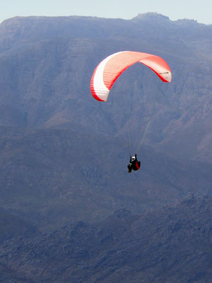
Lion's Head |
SW |
Basic |
450 |
|
Table Mountain |
N |
Sports |
1000 |

Remo: Potential für 60-80Km dann kommt Seewind und man steht am Boden
meist 20km+ Wind recht konstant Anschluss an 2. Rippe, recht absaufsicher
Contact: Rob Manzoni http://www.porterville.co.za
| Welcome to South Africa's most famous paragliding and hang
gliding site... Dasklip Pass near the town Porterville, locally
known as the small town with the BIG sky.
From the Flyers' Lodge we manage operations for you. Whether it is serving you with an ice-cold drink while you stare into the wide open plains from the comfort of our porch or giving advice on the weather, eating, staying the night or buying kit. It is all here for you.
At the Flyers' Lodge you will meet the nicest people from all over the world. |
| From the Flyers lodge we offer the following services to free flyers: |
|
| We also have a shop where one can purchase variety of paragliding gear. |
All Africa Open 2005 |
|||
| Date | : | 18-24 December 2005 (Sunday to Saturday) | |
| Venue | : | Dasklip Pass, near Porterville | |
| CIVL Ranking | : | Cat II | |
| Format | : | XC - Race or elapsed time; possibly an accuracy section. | |
| Glider limitation | : | None. | |
| Pilots flying prototypes or factory-modified gliders must provide written | |||
| authorisation from the manufacturer that the particular pilot is approved to fly that glider. | |||
| Pilots must also produce a load test certficate. | |||
| Task Verification | : | GPS - If not using Aircotec, Garmin or MLR GPS units, please bring your own | |
| download cable. |
|
||
| Registration | : | Flyers' Lodge | |
| : | Saturday, 4th from 16:00 | ||
| : | Sunday, 5th from 07:00 | ||
| Meet Centre | : | Flyers' Lodge | |
| : | 87 Main Street | ||
| : | Porterville | ||
| Provided | : | Map with TP's and GPS co-ordinates | |
| : | Rules | ||
| : | Daily transport to- and from take-off | ||
| : | Retrieve from en-route task roads | ||
| : | Ambulance and Paramedic service | ||
| : | Place medals - Gold, Silver and Bronze; also 'special' prizes | ||
| : | Comp T-shirt | ||
| Required | : | FAI Sporting Licence | |
| : | Licence from national association (IPPI card OK) | ||
| : | Insurance documentation | ||
| : | Radio (VHF-FM: 141.6 and 141.625) - NO VOX!! | ||
| : | Suitable Helmet | ||
| : | GPS | ||
| : | Reserve parachute (recently re-packed) | ||
| : | Line-plan for glider (to be handed in at registration) | ||
| : | Sensible footware | ||
| Entry Fee | : | TBA | |
| Scoring system | : | TP (Ulf) with RACE | |
| Accommodation | : | See: Resting | |
| Other facilities | : | Parachute-packing, glider repairs, site-briefings, daily weather briefings, | |
| cheap retrieve for free-flyers. | |||
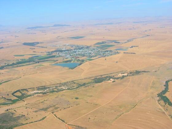
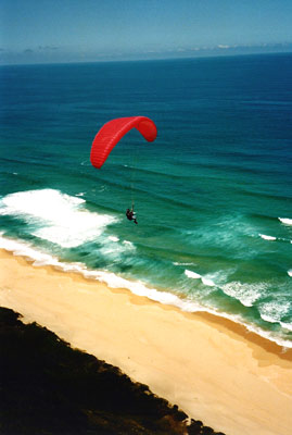
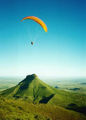
Porterville
 GRADE
: BASIC.(after 2 guided flights)
GRADE
: BASIC.(after 2 guided flights)
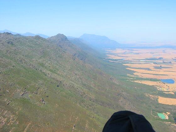
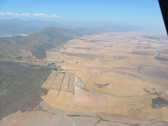
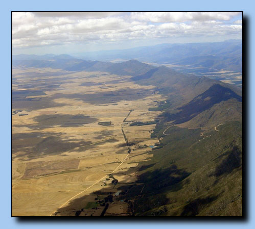
DESCRIPTION : Porterville is Cape Town's premier xc site. Hardy
scrub covers the dry and rocky mountain range. In summer, the fields below are
barren browns and blacks, having yielded their grains to the yearly harvest.
Ground temperatures can soar well into the thirties (*C) motivating good thermal
activity and healthy height gains. The front ridge offers a unique beginning to
some epic Cross-country flying. The Cedarberg Range which towers behind the
front ridge has only recently been explored by paragliders, and then only very
tentatively. It is a dry and dusty environment on the ground, but once airborne
one can appreciate the true beauty of the land. Wild, untamed mountains. Plains
stretching out from the foothills to the western horizon. Hidden, inaccessible
valleys (stay high!). Blue skies above. Almost unlimited landing areas out in
the flatlands. And thermals that leave you with no doubt that they are going UP.
You can almost be guaranteed flying here between November and March (averages at
4 good days in 7). If you are proficient at thermalling, 20km xc is an easy
goal. In winter (June - Sept), just after a cold front has passed, some thermic
and soaring conditions are still to be found over a much greener Porterville
valley.
WIND : W – SSW + anything
thermic GPS : +- S32º55΄37.4˝ E19º02΄10.9˝
LAUNCH : At the top of the DASKLIP PASS is a hangglider
ramp and a cut-away. The launch is covered with shade-netting, and is just above
the road. It is the regular site of competitions. I prefer to use the
alternative launch, PAMPOENFONTEIN,
which is higher and faces more directly into the
prevailing thermic cross-wind. The primary launch is a cliff-launch, so
is better suited to pilots with good ground-handling. The
thermals are usually stronger so you can get away quickly.
A wide ledge has been cleared and netting laid down. There is a large amount of
space in the surrounding fynbos as well, and an easy top-launch.
Toplanding is possible.
ALTITUDE : 550m high (800m asl), with airspace ceiling at 2900m
asl.
LANDING : Directly below launch is a field
to the right of a square forest (Grootelsbos). Land either side of the gravel
road coming in from Porterville. From Dasklip launch, land on the field
across the junction at the base of the pass. Most farmers in the area have no
problems with us landing on their lands. Simply avoid livestock, be friendly,
and don't bring your recovery vehicles onto their private land.
CAUTIONS : Make sure that you check the wind-direction around
the back of the mountain. Sometimes the takeoff site is in the lee of a strong
south-easter, and flying is not recommended until the heat of the valley has
raised the inversion high above the ridge. Midday thermals
can become incredibly strong, especially the house thermal to the left and right
of takeoff. The rocks below the launch-site are gnarly – avoid fiddling in your
harness and maintain good glider control until well clear of the ridge. In
strong thermic conditions it becomes difficult to judge your launch timing due
to the ledge which obscures your view – use an assistant if possible. Expect
your glider to surge as it bites into the wind.
DIRECTIONS : Take the N1, then turn left onto the N7 and drive
for 100km to Piketberg. At Piketberg, turn right towards Porterville. Turn left
at the T-junction and continue north. The first turning right is signposted
'Cardouw / Dasklip Pass'. After following this gravel road for 10km, you'll
reach the base of the pass (tarred). If you are going to park here to catch a
ride up with friends, please ensure that your vehicle is well off the road (up
against the fence), as the locals complain if we constrict the dangerous
intersection. When you reach the top, you will see a hangglider ramp on your
left. The paragliding launch site is directly above this. To reach
Pampoenfontein, continue on the road past Dasklip takeoff
around the back. After +- 3km, turn right (uphill). Road climbs out to the front
of the ridge.
SITE RECORDS FROM THE AREA : 151.4km N
(Simon Green), 112km S to Franschhoek (Greg Hamerton), 72km W (Allen).
ACCOMODATION
: Pampoenfontein -available
on farm. Call Gemma Carlsson on 082 564 5500. Dasklip
- Flyer's Lodge (Manzoni - 082 788 4398)
CARETAKERS
: Cape Albatross HG Club, Glen PG Club, the Carlssons.
Dasklip - Rob Manzoni.
PERMISSION :
Pampoenfontein - site fee of R20 payable in site fee box and
sign the indemnity. Dasklip - site fee R35 payable to Rob Manzoni.
Hermanus GRADE : BASIC
 DESCRIPTION
: Basic grade. Thermic and soaring. A long ridge shaped like a gentle
wave provides consistant flying conditions. Ridge-lift with a healthy sprinkling
of thermals makes for some interesting flying. Hermanus is generally a relaxing
place to fly, although the thermals and wind-shears can sometimes be quite
strong. In springtime, you may see whales in the bay.
DESCRIPTION
: Basic grade. Thermic and soaring. A long ridge shaped like a gentle
wave provides consistant flying conditions. Ridge-lift with a healthy sprinkling
of thermals makes for some interesting flying. Hermanus is generally a relaxing
place to fly, although the thermals and wind-shears can sometimes be quite
strong. In springtime, you may see whales in the bay.
WIND : S - SE, (SW on the western end).
GPS :
S34º24΄06˝ E19º14΄33˝
LAUNCH : Clearly defined area on the right of the scenic road,
with windsocks, netting, and benches for spectators. Please confine your
preparations to the area demarcated by the yellow rocks. In a SW, it is possible
to launch to the west side of the radio tower at the beginning of the ridge, to
soar the bowl overlooking the white pillars which marked 'Rotary Way' on the
drive up. The landing is then the soccer field across the main road.
ALTITUDE : 180m asl, with airspace ceiling at 2300m.
LANDING : The school fields, avoiding the cricket pitches
(special strip of hardened grass in the centre of the field). The rugby fields
closer to the ridge are okay, though beware of wind-shear as you approach the
protected lower layers. An emergency landing field is slightly to the left below
takeoff, a long, open plot between the houses. It is also possible to slope-land
at the base of the ridge, though be careful of the powerlines strung along a
third of the way up the slope. The field beside the graveyard is also open and
easy to negotiate. Toplanding is to the left of the takeoff site, close to the
road, or behind the fence.
CAUTIONS : Please do not land on any portion of the
golf-course. Beware of a prevailing Easterly wind; it wraps deceptively up the
takeoff site, but is in fact side-on to the ridge (from the left) and extremely
turbulent. Beware south-westerlies, which will become very turbulent as well.
At the end of the first unbroken section of the ridge to the left of takeoff
sits a white trig beacon. This point produces some heavy turbulence if you fly
above and behind it - be careful here, and stay clear and in front.
When top-landing, be careful of crossing the ridge too low, as the cliff edge
produces strong rotor turbulence near the front of the the ridge to the left of
the takeoff site.
Flying to the right of takeoff and crossing the first big gap in the ridge,
there is a set of high-tension powerlines which run down the mountainside. They
are difficult to see, especially in the afternoon.
DIRECTIONS : Take the N2 towards Caledon. After Sir Lowry's
Pass, and Houwhoek, you will descend the Houwhoek Pass and see the rolling hills
before Caledon. Turn left off the N2 on the R43, signposted 'Hermanus'. After
some distance you enter the outskirts of Hermanus, and an area of cheap
labourer's cottages on the left (behind a row of trees). Turn left at the white
pillars which are marked 'Rotary Way, scenic route'. Follow this tar road until
it becomes gravel, and continue for another 1km. You will see a signboard beside
the road 'Paragliding', and an obvious launch site overlooking the town and the
sea.
RECORD :
50km E (Abraham Meyer), 25km N to Caledon (Phil Bristow)
Ñ
HG : 100km route - Stanford to the E, Hawston to
W, back to the launchsite.
CARETAKER :
Glen PERMISSION : none needed, no site fee
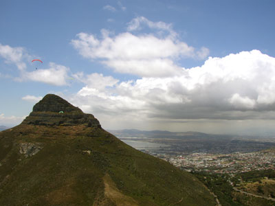
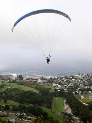
GRADE : BASIC (after 4 guided flights).
DESCRIPTION : Soaring. This is the home of the Glen Paragliding
Club, a consistent and beautiful site to fly, offering a superb panorama of
Clifton, Camps Bay, the Atlantic Ocean and the Twelve Apostles. As the sun moves
across to the West in the afternoon, Lion's Head begins to heat up and generate
a thermic, upslope breeze. Best flying is from 3pm onwards during windshadow
conditions. Parking is on the back (Cape Town) side of Lion's Head, then a stiff
hike is required up the gravel road and around to the front side. Because of the
spire-shape of the peak, the wind diverges quite dramatically around it, causing
a strong venturi (increase in wind speed) at both takeoff sites when it is
soarable. The wind is usually crossed from the left (south) at the topsite and
very strong, and crossed from the right (north-west) at the lower Silvertree
site. Please do not pioneer a new launch site somewhere else on the mountain -
it is a Nature Reserve.
WIND : W - SW soaring, thermic in the wind-shadow during SE
winds
LAUNCH : Lower launch is reached after 10minutes of walking. It
is a challenging launch through a silver-leaf tree grove. This is where the path
narrows from a jeep-track width into a hiking track with steps. Takeoff is clean
- a new gabionned stone-mattress has simplified the launch somewhat. This is
where to launch if there is soarable south-westerly wind blowing.
The 'Top site' is reached after another 10minutes of brisk walking, and is a
rocky launchsite with a stone/netting surface. The wind is usually crossed from
the left here, making good ground-handling and committed launch techniques
essential for a safe get-away.
ALTITUDES : Topsite is 450m asl, with ceiling at 1200m asl.
LANDING : On the grassed playing-field in front of LaMed, at
the Glen Country Club. The field is sometimes rented to the Camps Bay High
School, so try to have a minimum impact on any sports being played on the field.
The Camps Bay High School field (above the main road, to the left of the big
swimming pool) can be used as an alternative if it is not being used. During the
summer season the Municipality has asked us to please avoid landing on the
beaches (Camps Bay, Clifton, Glen) There is also a median strip of undeveloped
land between the upper main road and the lower main road, just above LaMed. The
lower slopes of Lion's Head can be used to slope-land in an emergency.
DIRECTIONS : Drive up through Cape Town and take Kloof Nek road
up to the pass between Lion's Head and Table Mountain. At the intersection, turn
right to Signal Hill and continue until the road levels out. You will find a
gravel carpark to the right of the road. The path to takeoff is on the left as
you reach the carpark.
CARETAKERS : Glen Paragliding Club
PERMISSION : Guidance by a local pilot at this highly visible
and sensitive site is essential. If
you’re a regular here, you're
expected to get a
Wild Card which supports the organisation who built the launch-sites
- the Cape
Peninsula National
Parks.
http://www.eternitypress.com/freshair/books.htm
 GRADE
: SPORT (no Basic pilots, >200flights + local instructor guidance needed).
GRADE
: SPORT (no Basic pilots, >200flights + local instructor guidance needed).
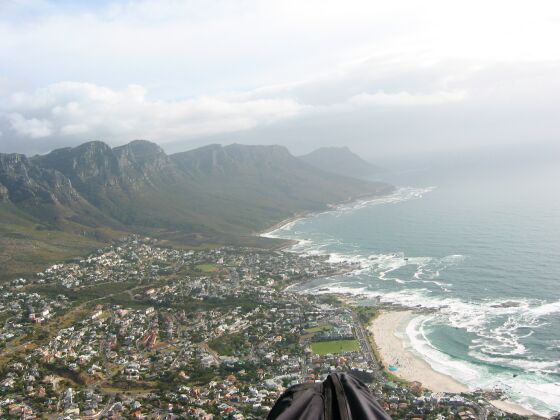
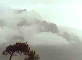
DESCRIPTION: Soaring. The most awesome and complex of the Peninsula
sites, overlooking Cape Town city. Table Mountain has a presence, an energy that
commands respect the moment you step outside the cablecar. The wind swirls
around the mountain in shifting currents, making takeoff judgement critical.
WIND : N, WSW, SE GPS : it's not that hard to miss.
Look up.
LAUNCH : A treacherous cliff-launch. N-wind : 'The Runway' is on
the front face, looking out over Cape Town, just beyond Platteklip Gorge. The
layout area is near the edge of the cliff, on flat rock. Expert handling of
reverse launch is essential. As you run towards the cliff, be prepared for the
lip rotor and turbulence that can cause sudden sink. Leaning forwards in the
harness, ready to run is essential, as you cannot afford to go off the edge with
a slack glider. SW wind : 'The Gully' faces SSW, and is behind the
cable-car station. You have to walk away from the station along the top of the
mountain for a few minutes to reach the launch site. Layout over the low bushes
and rocks. Immediately after takeoff, you will find yourself in a gully, soaring
along the south-facing north side of it. You soar out of the gully and onto the
main rock faces which form the Twelve Apostles. Light ESE : Maclears
Beacon' site is 100m E of Maclear's Beacon, just below a rocky ridge (30 minutes
hike from the Upper Cablecar Station in an E direction).
ALTITUDE : 1000m asl, airspace ceiling is at 1200m.
LANDING : LaMed, or the more challenging rugby field in Upper Orange St.
CAUTIONS : Don't take a chance if you feel unhappy. This site is
extremely unforgiving, and local knowledge is invaluable. Two signoff flights
are required from each launch site before going completely solo, it's that
difficult.
DIRECTIONS : Follow the signs through Cape Town to the Cable-car (up
Kloof Nek road, turn left at the crest).
CARETAKER : Glen PG Club (who keep the register of Approved TM pilots).
PERMISSION : You need to be properly licensed and
guided to fly here. 2 guided flights are needed from each launch site
before flying solo. If you tell the ticket office that
you are paraglider when you buy your Cable Car one-way ticket (up) you should be
able to get a free return ride (down) should you not fly. Regular pilots should
buy a Wild Card (covers all sites in Cape Peninsula Park).
Marttin Arnold & Des:
Gute Infratruktur!
Preiswert!
Stressfreier: In alle 4 Windrichtungen Strassen!
http://www.pottiesbnb.co.za/deutsch.html
| Latitude | -30.595043 |
|---|---|
| Longitude | 25.489642 |
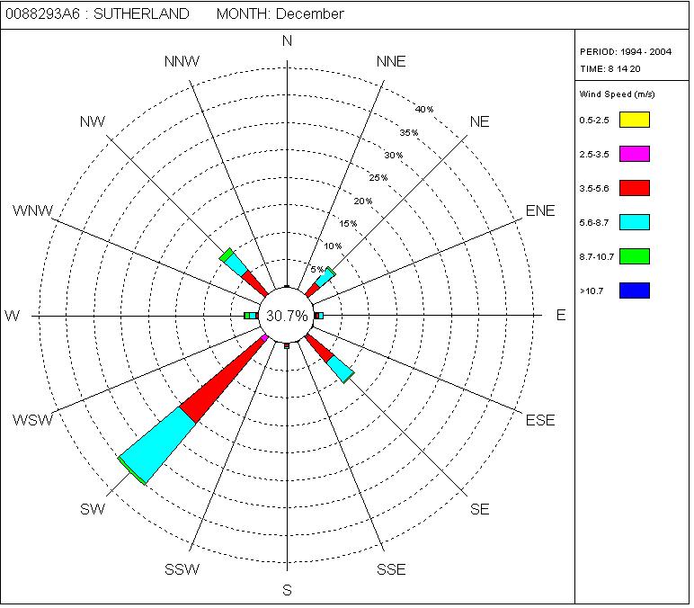
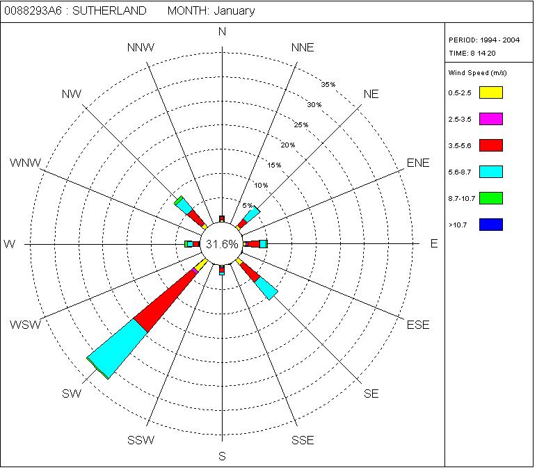
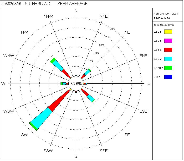
South African Record Encampment In Oz-Report for November 2005
minnaar and de kock <minnaarendekock@yebo.co.za> writes:Sutherland, South Africa will be the location for a record breaking encampment
from the 5th to the 12th of November, 2005. The current South African record, unofficial, sits at
395km flown by Frank Jachinsky. The organiser has chosen Sutherland for the favourable winds,
predominant South Westerly opening up the whole of the Karoo to the North East
up to and past De Aar. It is a mountain launch.
The Karoo is a semi desert area with excellent XC potential. The well known trough line situated
over the area makes South Africa a record breaking destination for sail plane pilots from all over the world.
Interested pilots can contact Andre Van der Lingen mdk@yebo.co.za.
Info on the trough line can be viewed at : http://www.gariepgliding.com/
Früher: CTRs! Problematisches Gelände auf grossem Gebiet,
ohne Strassen, nur mit eigenem Rückholer
-> Wird Heute gar nicht mehr beflogen von den Einheimischen wg. De Aar
|
SITE NAME |
Best in | GRADE | Altitude |
| Map of Africa | SE | Basic | 120 |
| Paradise Ridge | SSW | Basic | 90 |
| Graaff-Reinet | S | Sports | 1400 |
 Map
of Africa :: Garden
Route BASIC
Map
of Africa :: Garden
Route BASIC
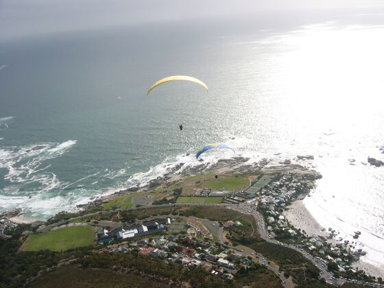
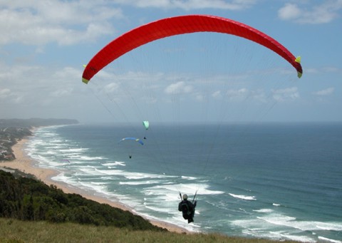
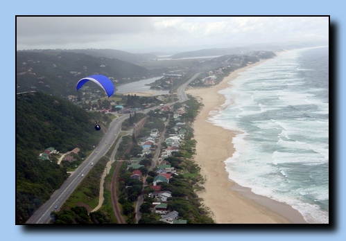
DESCRIPTION : A mellow site with a fantastic view, overlooking the
tranquil Indian Ocean and the holiday town of Wilderness. A favourite site for
flying schools.
WIND : S - SE
GPS :
S33º59΄31˝
E22º33΄36˝
LAUNCH : a gently-sloped grass field which becomes steeper - perfect!
ALTITUDE : 120m above the waves, airspace ceiling at 450m, George Airport
to NW of the site who must be notified.
LANDING : Anywhere on the beach, well clear of sunbathers and
beach-goers. In busy season, please land beyond (to the east) of the rocks which
border the first section of beach, as that is the most popular area for bathers.
CAUTIONS : Avoid the sea at all costs, as the surf is powerful. If there
are catspaws (streaks of wind) showing on the sea, beware of a dramatic increase
in wind, which can blow you over the back (go and have a look over the back, you
won't ever want to fly in strong wind!) Once the sea has white-caps on it, it is
usually too strong for safe soaring. If you soar too far to the right, you'll
end up in the sea. When the wind is SW, beware! for it curls up to takeoff, and
appears flyable, varying between W and S at the top. As soon as you fly out, you
encounter heavy sink and turbulence, which has put many pilots into the trees.
When the wind is very E, it is similarly risky to launch. Beware of powerlines
to the West.
DIRECTIONS : Take the N2 to Wilderness (just beyond George on the Cape
south coast). As you enter town, turn left past the garage, and drive around the
Wilderness Karos Hotel, turning left at the intersection beyond it. Bear right
on this road which becomes very narrow and clim bs steeply, until it crests the
hill and passes a little shop. "Map of Africa" signposts the turn to the left.
Follow this road until you come to the signposted flying site.
If you're stuck without a retrieve vehicle, there is a path which leads through
the forest, beginning from the carpark area.
RECORD : Tom Edwards, to Buffalo Bay
CARETAKER : Jan Minnaar (lessee). No site fees, sponsored by Cloudbase
Paragliding School.
PERMISSION : Contact the local club and the George ATC (044 876 9210)
before flying. Please obey the rules posted on the site board, as the land-owner
is sensitive.
|
http://www.cloudbase-paragliding.co.za/sites.htm Clickable
Photos!
|
 Paradise Ridge :: Garden
Route BASIC
Paradise Ridge :: Garden
Route BASIC
DESCRIPTION : Soaring heaven. 7km of virgin vegetation draped over a
continuously perfect ridge, with the sparkling sea at its feet, and the sky
overhead.
WIND : S - SW
GPS :
S34º00΄03˝
E22º40΄03˝
LAUNCH : Cliff-launch, with clean and level layout area behind the crest.
Walk 500m from the carpark in a semi-circle east, then south until you are on
the cliffs.
ALTITUDE : 100m, airspace 600m.
LANDING : If the wind drops off and you are soaring below the level of
the top of the ridge, turn back and try to land on the beach below the launch
site, where there is a path up to the top. Or head for the Kleinkrantz dunes,
because a 7km walk in the soft sand can be murderous. Alternatively, land near
the east end of the ridge and walk around to Swartvlei, where there is a carpark
and easy retrieve.
CAUTIONS : If the wind is WSW, turn back towards Wilderness regularly to
check your penetration as you progress east along the ridge. The venturi at the
eastern end can become strong, pulling you around into the treacherous lee-side
bay at Swartvlei. When launching, beware of the sudden impact of the wind - your
pullup begins in wind-shadow. Step towards your wing, or use an assistant. No
smoking.
DIRECTIONS : Fly across from the dunes at Kleinkrantz. Alternatively,
pass the turning to Kleinkrantz on the N2, and continue for exactly 4km. You'll
pass the Kleinkrantz Sand Quarry on your left. An unmarked turning at the 4km
point to the right accesses a compacted sand road, which will soon pass a deep
sand quarry. The signs will eventually guide you to the parking area. Do not
attempt the 4x4 routes without one - the sand is very soft, and you want to fly,
not dig. This is private land so contact the locals first for current status
CARETAKER : Skywings PERMISSION : Bruce Watney. You may
be charged an access fee.
 Graaff-Reinet
:: Eastern Cape SPORT (Basic under guidance)
Graaff-Reinet
:: Eastern Cape SPORT (Basic under guidance)
DESCRIPTION : A big site with butt-kicking thermals in the Karoo
semi-desert.
WIND : SW - NE
GPS :
S32º15΄00˝
E24º30΄00˝
LAUNCH : Rocks and scrub, with shade-cloth on the main S site (above the
carpark, to the righ t of the top of the stairs). The N launch amongst the scrub
below the carpark, E launch beyond the Toposcope.
ALTITUDE : 700m high (1400m asl), no airspace ceiling.
LANDING : The quarry on the north side of Spandau-kop (south-west edge of
town) provides a good clear area with a windsock. Any of the school fields in
town are fine if you have the height to reach them, though avoid sports
practices.
CAUTIONS : Thermic activity can become severe on sunny days, even in
winter. SW winds, which wrap around to b ecome a false S on launch, can be very
turbulent if you attempt to round the Valley of Desolation peaks to the right.
Spandaukop (in front of the S launchsite) produces rotor if the wind is strong.
Strong wind launches are risky - it's easy to be blown over the spine into the
pit.
DIRECTIONS : Take the N1 to Beaufort West, turn right to Aberdeen /
Graaff-Reinet. When you arrive in town, visit Graham Botha at Botha's Garage on
the east side of town, then drive out of the north-western side of town, past t
he campsite to the site. After 3km turn left into the Nature Reserve, and bear
left to follow the road up to the 'Toposcope' viewsite which faces east.
RECORD : Tristam Burrell, 132km, Jan 2000. CARETAKER :
Graham Botha (0491) 23716 PERMISSION : permit for Nature Reserve
obtainable from caretakers.
Eastern Cape
| No. | Site Name | Longitude (S) | Latitude (E) | Wind direction(s) | Rating | Height (m) |
| 1. | Bachelors Hill id:17 | 311500 | 280500 | BASIC | 150 | |
| 2. | Bedford id:21 | 323800 | 261000 | NNW-W-SW SE-Basic | BASIC | 550 |
| 3. | Bushmans id:10 | 335500 | 250500 | NW | BASIC | 200 |
| 4. | Dunes id:2 | 325500 | 275500 | BASIC | 0 | |
| 5. | Eagle Rock id:15 | 310500 | 281000 | BASIC | 350 | |
| 6. | Glen Cullen Fire Tower id:16 | 310500 | 281500 | BASIC | 330 | |
| 7. | Harnett id:5 | 331500 | 262900 | SW,S,SE | BASIC | 150 |
| 8. | High Dunes id:3 | 331000 | 275000 | BASIC | 0 | |
| 9. | Highlands Farm id:7 | 331900 | 262500 | SW,S,SE | BASIC | 150 |
| 10. | Hoggsback id:1 | 323400 | 265100 | BASIC | 0 | |
| 11. | Kirkwood id:22 | 332300 | 252200 | SW-S | BASIC | 450 |
| 12. | Lady Slipper id:11 | 335000 | 251500 | S10, N20 | BASIC | 250 |
| 13. | Maitlands Bottom id:12 | 335900 | 252000 | S | STUDENT | 50 |
| 14. | Maitlands Top id:20 | 335900 | 252000 | S | STUDENT | 120 |
| 15. | Mountain Drive id:8 | 332000 | 261500 | NE 15-25 km/h | BASIC | 150 |
| 16. | Mullersberg id:19 | 332200 | 252500 | SW,S,SE | BASIC | 450 |
| 17. | Ntywenka id:18 | 310500 | 275500 | BASIC | 0 | |
| 18. | Post Tower id:9 | 335500 | 244500 | BASIC | 0 | |
| 19. | Prentjiesberg id:14 | 311000 | 281000 | BASIC | 0 | |
| 20. | Rondebosch Ridge id:23 | 335900 | 244700 | S,N | BASIC | 70 |
| 21. | Valley of Des. id:4 | 321500 | 243000 | S-E-NE | BASIC | 600 |
| 22. | Westo id:6 | 331500 | 262000 | SW,S,SE | BASIC | 150 |
Western Cape
| No. | Site Name | Longitude (S) | Latitude (E) | Wind direction(s) | Rating | Height (m) |
| 1. | Bettys Bay id:134 | 342120 | 185406 | ESE, SE, S, SSW | STUDENT | 145 |
| 2. | Blouberg Hill id:204 | 334523 | 182755 | NW-SW | SPORT | 0 |
| 3. | Burgerspass id:157 | 334500 | 195000 | N/S | BASIC | 350 |
| 4. | Ceres-Gydo Pass id:150 | 331412 | 191928 | SE light | BASIC | 1000 |
| 5. | Constantiaberg id:135 | 340500 | 181700 | W, SE | SPORT | 100 |
| 6. | Dasklip id:155 | 325000 | 190500 | SW, W, NW | STUDENT | 250 |
| 7. | Devils Peak id:136 | 335646 | 182621 | NE, N, NNW | BASIC | 400 |
| 8. | Doringkraal id:167 | 333100 | 184300 | S-E | STUDENT | 150 |
| 9. | Du Toits Kloof id:168 | 334200 | 190500 | W | SPORT | 300 |
| 10. | Eselsfontein id:162 | 325200 | 190600 | SW | BASIC | 300 |
| 11. | Flyers Lodge id:156 | 330018 | 185934 | ANY | STUDENT | 0 |
| 12. | Franschoek id:151 | 335412 | 190926 | NW light | SPORT | 250 |
| 13. | Gordons Bay id:152 | 341500 | 185000 | NW | SPORT | 350 |
| 14. | Haystax id:186 | 0 | 0 | SE | BASIC | 140 |
| 15. | Hermanus id:153 | 342406 | 191433 | SE,S,SSW | BASIC | 200 |
| 16. | Inverdoorn id:177 | 330600 | 194700 | ANY | STUDENT | 0 |
| 17. | Kalkbay id:137 | 341000 | 182800 | SE | SPORT | 300 |
| 18. | Kanonkop id:138 | 335000 | 185500 | SW,NW | BASIC | 250 |
| 19. | Katbakkies Pass id:169 | 325400 | 193300 | W-SW | SPORT | 200 |
| 20. | Klein Kanonkop id:159 | 335100 | 185400 | S, SE | SPORT | 350 |
| 21. | Kommetjie id:139 | 341000 | 181700 | NW,W | SPORT | 350 |
| 22. | Kommetjie id:140 | 341000 | 181700 | Top W | BASIC | 150 |
| 23. | Lions Head id:141 | 335603 | 182314 | SE windshadow, SW, W | BASIC | 200 |
| 24. | Little Lions Head id:165 | 340048 | 182045 | BASIC | 0 | |
| 25. | Llandudno id:142 | 340034 | 182032 | NW | BASIC | 350 |
| 26. | Maniacs id:143 | 331000 | 182000 | WNW, SW, S, SE | BASIC | 250 |
| 27. | Misty Cliffs id:171 | 341200 | 182100 | SW | BASIC | 300 |
| 28. | Montagu id:172 | 334400 | 195400 | N,S | SPORT | 1300 |
| 29. | Noordhoek-Fence id:144 | 340415 | 182253 | SW,W,NW | SPORT | 50 |
| 30. | Noordhoek-SW id:145 | 340426 | 182254 | SW,S,SE | BASIC | 350 |
| 31. | Ou Kaapse Weg id:173 | 340600 | 182500 | NE | SPORT | 100 |
| 32. | Paarl Rock id:154 | 334000 | 184500 | N,Thermic SE | BASIC | 250 |
| 33. | Piekernierskloof Pass id:174 | 323700 | 185700 | SW | BASIC | 200 |
| 34. | Piketberg id:161 | 325000 | 184500 | E | BASIC | 0 |
| 35. | Porterville Airstrip id:175 | 330100 | 190000 | SE,NW | STUDENT | 0 |
| 36. | Saldanha id:163 | 330400 | 175500 | SE | BASIC | 0 |
| 37. | Scarborough id:146 | 341500 | 181800 | WNW, SW, S | BASIC | 350 |
| 38. | Signal Hill-Bench id:147 | 335517 | 182353 | NW | SPORT | 250 |
| 39. | Signal Hill-Point id:148 | 335502 | 182408 | N, WNW 15-25km/h best: N 20km/h N, WNW 15-25km/h | SPORT | 250 |
| 40. | Silvermine id:164 | 340420 | 182250 | BASIC | 0 | |
| 41. | Sir Lowrys Pass id:158 | 340855 | 185539 | W, SW, WNW | SPORT | 350 |
| 42. | Strandfontein id:176 | 303300 | 172400 | NW-SW | BASIC | 43 |
| 43. | Table Mountain Runway id:149 | 335744 | 182441 | SW, W, NE (light SE) | SPORT | 250 |
| 44. | Vanrhynspas id:160 | 312000 | 190500 | NW | BASIC | 500 |
| 45. | Waboomberg id:166 | 331500 | 192800 | SE-SSW | SPORT | 1000 |
| 46. | Wolfgat id:170 | 340300 | 183700 | S-SE | BASIC | 60 |
North West Province
| No. | Site Name | Longitude (S) | Latitude (E) | Wind direction(s) | Rating | Height (m) |
| 1. | Eagles Nest, Tlhabane id:178 | 254000 | 271000 | E/W | STUDENT | 270 |
| 2. | Hartebeespoort Dam id:191 | 254000 | 281000 | S, NE, N, NW | SPORT | 300 |
| 3. | Kombagana id:181 | 254950 | 272520 | N,S,NW | BASIC | 0 |
| 4. | Leopardsrock id:182 | 254600 | 272100 | W,NW | STUDENT | 250 |
| 5. | Suurplaat id:180 | 254500 | 272500 | NW-NE | BASIC | 500 |
| 6. | Vryburg Airfield id:179 | 265500 | 244000 | ANY | BASIC | 0 |
| 7. | WigWam id:194 | 0 | 0 | NE, N | UNKNOWN | 0 |
6. Mpumalanga
| No. | Site Name | Longitude (S) | Latitude (E) | Wind direction(s) | Rating | Height (m) |
| 1. | Bambi id:47 | 252900 | 302000 | E | STUDENT | 250 |
| 2. | Bulembu Road id:58 | 254500 | 310500 | E,NE,W | STUDENT | 200 |
| 3. | Densa id:48 | 252000 | 305000 | E | STUDENT | 200 |
| 4. | Doringkop id:56 | 253000 | 295000 | any | BASIC | 250 |
| 5. | Gods Window id:46 | 245000 | 305000 | NE/E/SE | SPORT | 500 |
| 6. | Kaapse Hoop id:49 | 254000 | 304500 | S | BASIC | 200 |
| 7. | Kriel id:55 | 261500 | 291500 | ANY | BASIC | 0 |
| 8. | Lone Tree id:45 | 254500 | 311000 | NW-NE | STUDENT | 500 |
| 9. | Long Tom Pass id:57 | 250800 | 303500 | BASIC | 0 | |
| 10. | Lydenburg id:59 | 250900 | 302000 | E | BASIC | 1000 |
| 11. | Mount Carmel id:50 | 252000 | 304500 | SE/SW | STUDENT | 350 |
| 12. | Ngodwana id:51 | 254000 | 304000 | N | STUDENT | 500 |
| 13. | The Farm id:53 | 254000 | 303500 | BASIC | 0 | |
| 14. | Vaal Kop id:44 | 254530 | 304000 | E/W | STUDENT | 400 |
| 15. | Wakkerstrom id:52 | 272000 | 301500 | STUDENT | 300 | |
| 16. | Witbank Dam id:54 | 255000 | 292000 | ANY | STUDENT | 0 |
8. Northern Cape
| No. | Site Name | Longitude (S) | Latitude (E) | Wind direction(s) | Rating | Height (m) |
| 1. | De-Aar id:196 | 0 | 0 | ANY | STUDENT | 0 |
| 2. | Edgehill id:185 | 273500 | 233000 | BASIC | 0 | |
| 3. | Hotazel Airstrip id:184 | 271000 | 225500 | N/S | BASIC | 0 |
| 4. | Kuruman Airfield id:183 | 272500 | 232500 | N/S or E/W | BASIC | 0 |
10. Southern Cape
| No. | Site Name | Longitude (S) | Latitude (E) | Wind direction(s) | Rating | Height (m) |
| 1. | Arch Rock id:103 | 340000 | 232820 | SW / SE | BASIC | 120 |
| 2. | Barrydale id:130 | 335500 | 204500 | N,S | BASIC | 0 |
| 3. | Bonnievale id:125 | 335240 | 215157 | BASIC | 0 | |
| 4. | Bredasdorp Airfield id:123 | 343948 | 200329 | ANY | BASIC | 0 |
| 5. | Brenton id:99 | 340425 | 230110 | SW-SSE | STUDENT | 100 |
| 6. | Brenton Eagles Nest id:108 | 340330 | 230000 | BASIC | 270 | |
| 7. | Brenton View id:131 | 340400 | 230100 | S | SPORT | 200 |
| 8. | Buffles Bay id:109 | 340500 | 225835 | ESE-ESW | BASIC | 5 |
| 9. | Castleton id:105 | 340329 | 232140 | WSW - SW | BASIC | 150 |
| 10. | Cloud 9 id:110 | 340002 | 224640 | BASIC | 0 | |
| 11. | Dana Bay id:117 | 341221 | 220137 | NW-NNE | BASIC | 0 |
| 12. | Du Toits id:118 | 334901 | 223057 | NW-NNE | BASIC | 825 |
| 13. | Eagles Nest id:198 | 0 | 0 | S-SW | SPORT | 200 |
| 14. | Gansbaai id:129 | 343430 | 192601 | SW-S-SE | BASIC | 250 |
| 15. | Gerickes id:112 | 340158 | 224850 | E-ESE | BASIC | 160 |
| 16. | Hartenbos id:116 | 340740 | 221500 | ESE-SE | BASIC | 0 |
| 17. | Hersham id:115 | 340322 | 221500 | SSE-SW | BASIC | 40 |
| 18. | Holiday Inn id:100 | 335959 | 223648 | SW,S | BASIC | 80 |
| 19. | JB id:200 | 0 | 0 | SPORT | 450 | |
| 20. | Jongens Fontein id:122 | 342500 | 212000 | SE-SW | BASIC | 0 |
| 21. | Kelershoogte id:120 | 334218 | 220800 | BASIC | 0 | |
| 22. | Kleinkrans Dunes id:101 | 340038 | 223931 | WSW-SW | STUDENT | 46 |
| 23. | Kleinkrantz car park id:114 | 340035 | 223954 | WSW-SW | BASIC | 25 |
| 24. | Knysna Tower id:197 | 0 | 0 | NNE - NW | SPORT | 190 |
| 25. | Map of Africa id:102 | 335931 | 223336 | SSE,S | BASIC | 280 |
| 26. | Nordhoek Peak id:127 | 340421 | 182248 | BASIC | 0 | |
| 27. | Oudtshoorn Air Field id:119 | 333600 | 221100 | N-SW(E-W) | BASIC | 0 |
| 28. | Paradise Ridge id:113 | 340003 | 224003 | SW | BASIC | 75 |
| 29. | Pencils id:202 | 0 | 0 | SE-WSW | SPORT | 160 |
| 30. | Piesang Valley id:104 | 340330 | 232240 | SW | BASIC | 80 |
| 31. | Pilots View id:107 | 340500 | 230420 | SSE | BASIC | 70 |
| 32. | Rondebossie id:126 | 334557 | 184003 | BASIC | 0 | |
| 33. | Sedgeview id:111 | 340038 | 224801 | SSE-SW | STUDENT | 160 |
| 34. | Serpentine id:132 | 335931 | 223400 | SW-SSE | SPORT | 130 |
| 35. | Swartberg Pass id:121 | 332001 | 220030 | SSW-SSE | BASIC | 1500 |
| 36. | Swellendam id:124 | 335500 | 202000 | BASIC | 0 | |
| 37. | Table Mountain SW Gully id:128 | 335737 | 182420 | BASIC | 0 | |
| 38. | Tussen Riviere id:201 | 0 | 0 | S-SE | STUDENT | 0 |
| 39. | Uplands id:106 | 340500 | 231800 | SW-SSE | BASIC | 430 |
| 40. | Wilderness Beach Hotel id:199 | 0 | 0 | WSW-SW | BASIC | 36 |
| Competition |
| Comp Title: | All Africa |
| Dates: | Sun 18 Dec 05 - Sat 24 Dec 05 |
| Venue: | Dasklip (Porterville) |
| Type: | Cat 2 |
| Category: | 2 |
| Contact | www.porterville.co.za |
| Mixed Links |
http://www.parastep.de/afrika/za03/index.htm 10 Seiten viel Text
| Forum |
Tips aus dem Forum:
|
die gastmitgliedschaft bei SAHPA ( http://www.paragliding.co.za/sahpa/ ) ist obligatorisch um legal als gastpilot in SA fliegen zu dürfen. ich kenne einige, die sich die 300 rand gespart haben (ca. 35€), aber wenn's kracht, dann hat man wohl ein rechtliches und damit auch ein versicherungstechnisches problem als ausländer. und das kann schon durchaus mal passieren. da v.a. die xc-gebiete sehr abgelegen und bei rettungen oft nur mit heli gescheit zugänglich sind sollte man hier evtl. auf nr. sicher gehen... (wir haben z.B. in porterville einen südafrikanischen fliegerkameraden mit heli-hilfe tot bergen müssen...) die verhältnisse sind jedenfalls nicht immer einfach, und wenn du ohne guide bzw. fliegergruppe unterwegs bist, dann kann ich dir rob manzoni aus kapstadt als helfer echt empfehlen. ihm gehört eine flugschule und die pilolt's lodge in porterville. und auch den dortigen startplatz "dasklip" hat er vor ein paar jahren gekauft. klingt jetzt nach sehr geschäftstüchtig, aber ich habe rob als fairen und kompetenten menschen kennen gelernt, der mir sehr viel geholfen hat und wenn überhaupt etwas dann nur vernünftige preise verlangt hat. hier seine kontaktdaten: (021) 434-2011 oder mobil 082-788-4398 mail:<Airborne@telkomsa.net> oder einfach im netz nach seinem namen und stichwort paragliding suchen. |
| Reiseanbieter |
Oz Report, v9, #157
South African TourThree weeks in South Africa Pete Ablitt <> writes: Silent Wings Hang Gliding will be touring South
Africa again this season. The itinerary is currently evolving
but will have an emphasis on cross country flying. We will start
in Cape Town around 24th December and end in Cape Town around
15th January. We will fly sites in Cape Town, the Garden Route,
the flatlands of the Karoo and the endless ridges and open
farmland of Porterville our prime xc mountain launch site. The
South African Nationals are from 3rd to 10th January so this may
be a good chance to spend a few days at Porterville. |
Flugschule Chiemsee
| Südafrika |
23.Januar - 09.Februar 2006 Wir fliegen direkt nach Kapstadt mit Anschlußflug nach George. Nur 20 Minuten von Wilderness entfernt ist es der ideale Ausgangspunkt für unsere Rundreise. Mehrere golfplatzartige Startplätze mit kilometerlangen Soaringmöglichkeiten erwarten uns: Map of Africa, Sedgeview, Gerricke's Point, Holiday Inn, Kleinkrantz, Paradise Ridge - die Möglichkeiten in Fluggebieten der Extraklasse scheinen fast unerschöpflich! Ein unvergessliches Erlebnis wird auch ein Besuch der nahegelegenen Game Farm Botlierskop mit der Möglichkeit einer game drive (Tierbeobachtung mit Landrovers) und anschließendem Abendessen im luxuriösen Hauptgebäude 40 m über den Tieren sein. Die Möglichkeit einer eintägigen Safari (Shamwari game resort) per Cessna (nicht im Preis inbegriffen) rundet das Programm in Wilderness ab. Entlang der weltberühmten Gardenroute führt uns die Reise über einen Abstecher nach Hermanus und den Sir Lowry's Pass in das thermisch aktive Porterville, wo uns ein ganzes Haus mit Doppelzimmern und kleinem Pool zur Verfügung steht. Porterville war schon häufig Austragungsort für internationale Wettbewerbe. Eine XC-trächtige Ridge garantiert von hier weitreichende Streckenflüge über einer beeindruckenden Landschaft. Im Anschluss erwartet uns in Kapstadt, einer der schönsten Städte der Welt, eine atemberaubende Unterkunft am Fuße des Tafelberges. Flüge vom Signal Hill, dem Lion's Head inmitten der Cap Metopole, oder an der Noordhoek, ein Abstecher in das weltbrühmte Weinanbaugebiet von Stellenbosch sowie ein Besuch an der Waterfront mit Abendessen am Hafen runden diese Reise der Superlative ab. Neu: ab dem 1.2. besteht die Möglichkeit bei entsprechender Nachfrage in Porterville ein Streckenflugseminar mit Rüchholservice zu organisieren. Der Preis von 2290,- € beinhaltet: Flug mit LTU von München, Transfers, Rückholservice, Übernachtung mit Frühstück und Flugbetreuung (Anschlussflug von jedem deutschen Flughafen ohne Mehrpreis!) Zusatzprogramm: Eintägige Safari mit Flug von Plettenberg Bay nach Shamwari 320 €.
|
| Mietwagen, Flüge etc nach SA |
--- END of DOC ---
Noch eine Liste aller Flying Sites:
http://www.paragliding.co.za/sites/ALL2003BYREGION.html
| AREA | ID | NAME | Latitude S | Longitude E | WIND | REMARKS | CONTACT | REGION | CLUB | CLOSEST TOWN | RATING | TANDEM | Altitude Meters | Height Meters | Winch | Wind-IFL |
|---|---|---|---|---|---|---|---|---|---|---|---|---|---|---|---|---|
| Eastern Cape | 1 | Hoggsback | 323400 | 265100 |
|
|
Richard Grant, | Eastern Cape | Hawkwind | Alice | BASIC | Yes |
|
|
No | 0 |
| Eastern Cape | 2 | Dunes | 325500 | 275500 |
|
|
Alan Browne, | Eastern Cape | Hawkwind | East London | BASIC | Yes |
|
|
No | 0 |
| Eastern Cape | 3 | High Dunes | 331000 | 275000 |
|
|
Alan Browne, | Eastern Cape | Hawkwind | East London South | BASIC | Yes |
|
|
No | 0 |
| Eastern Cape | 4 | Valley of Des. | 321500 | 243000 | S-E-NE |
|
Andy Wiggils, | Eastern Cape | Hawkwind | Graaf Reinet | BASIC | Yes | 1200 | 600 | No | 0 |
| Eastern Cape | 5 | Harnett's Farm | 331500 | 262900 | SW,S,SE < 15km/h | On private land. Local Pilot must be contacted to arrange for flying. | Richard Grant, | Eastern Cape | Hawkwind | Grahamstown | BASIC | Yes |
|
150 | No | 0 |
| Eastern Cape | 6 | Westo | 331500 | 262000 | SW,S,SE < 15km/h | On private land. Local Pilot must be contacted to arrange for flying. | Richard Grant, | Eastern Cape | Hawkwind | Grahamstown | BASIC | Yes |
|
150 | No | 0 |
| Eastern Cape | 7 | Highlands Farm | 331900 | 262500 | SW,S,SE < 15km/h | On private land. Local Pilot must be contacted to arrange for flying. | Richard Grant, | Eastern Cape | Hawkwind | Grahamstown | BASIC | Yes |
|
150 | No | 0 |
| Eastern Cape | 8 | Mountain Drive | 332000 | 261500 | NE 15-25 km/h |
|
Richard Grant, | Eastern Cape | Hawkwind | Grahamstown | BASIC | Yes |
|
150 | No | 0 |
| Eastern Cape | 9 | Post Tower | 335500 | 244500 |
|
|
Mike Tabeling, | Eastern Cape | Hawkwind | Humansdorp | BASIC | Yes |
|
|
No | 0 |
| Eastern Cape | 10 | Bushmans | 335500 | 250500 | NW |
|
Roger Thomas, | Eastern Cape | Hawkwind | Port Elizabeth | BASIC | Yes |
|
200 | No | 0 |
| Eastern Cape | 11 | Lady Slipper | 335000 | 251500 | S10, N20 |
|
Roger Thomas, | Eastern Cape | Hawkwind | Port Elizabeth | BASIC | Yes | 350 | 250 | No | 0 |
| Eastern Cape | 12 | Maitlands Bottom | 335900 | 252000 | S |
|
Roger Thomas, | Eastern Cape | Hawkwind | Port Elizabeth | STUDENT | Yes | 120 | 50 | No | 0 |
| Eastern Cape | 114 | Bedford | 324000 | 260500 |
|
Arrange 1 day before | , | Eastern Cape | Hawkwind | Port Elizabeth | BASIC | Yes |
|
|
No | 0 |
| Eastern Cape | 146 | Prentjiesberg | 311000 | 281000 |
|
|
John Kent, | Eastern Cape |
|
Maclear | BASIC | Yes |
|
|
No | 0 |
| Eastern Cape | 147 | Eagle Rock | 310500 | 281000 |
|
|
Hendrik Britz, | Eastern Cape |
|
Maclear | BASIC | Yes | 500 | 350 | No | 0 |
| Eastern Cape | 148 | Glen Cullen Fire Tower | 310500 | 281500 |
|
|
Nardus du Preez, | Eastern Cape |
|
Maclear | BASIC | Yes |
|
330 | No | 0 |
| Eastern Cape | 149 | Bachelors Hill | 311500 | 280500 |
|
|
John Kent, | Eastern Cape |
|
Maclear | BASIC | Yes |
|
150 | No | 0 |
| Eastern Cape | 150 | Ntywenka | 310500 | 275500 |
|
|
Hendrik Britz, | Eastern Cape |
|
Maclear | BASIC | Yes |
|
|
No | 0 |
| Eastern Cape | 155 | Mullersberg | 332200 | 252500 | SW,S,SE | road fee, arrange before with OGI/Hawkwind, 4x4 only | Mike Botha, | Eastern Cape | Hawkwind | Kirkwood | BASIC | Yes | 650 | 450 | No | 0 |
| Eastern Cape | 159 | Maitlands Top | 335900 | 252000 | S | Contacted OGI for permit to use the Top take off | Ocean Gliders, | Eastern Cape | Hawkwind | Port Elizabeth | STUDENT | Yes | 120 | 120 | No | 0 |
| Eastern Cape | 212 | Bedford | 323800 | 261000 | NW,SE, | Sensitive landowners |
|
Eastern Cape | Hawkwind | Port Elizabeth | BASIC | Yes | 1360 | 550 | No | 0 |
| Eastern Cape | 214 | Kirkwood | 332300 | 252200 | SW-S |
|
|
Eastern Cape | Hawkwind | Port Elizabeth | BASIC | Yes | 600 | 450 | No | 0 |
| Eastern Cape | 215 | Rondebosch Ridge | 335900 | 244700 | S,N |
|
|
Eastern Cape | Hawkwind | Port Elizabeth | BASIC | Yes | 140 | 70 | No | 0 |
| Free State | 13 | Botshabelo | 291500 | 264500 | W |
|
, | Free State | Fly Extreme PG Club | Bloemfoentain | STUDENT | Yes | 1700 | 500 | No | 0 |
| Free State | 14 | Thaba Nchu | 291000 | 264500 |
|
|
, | Free State | Fly Extreme PG Club | Bloemfoentain | BASIC | Yes |
|
250 | No | 0 |
| Free State | 15 | Dealsville | 284000 | 254500 |
|
|
, | Free State | Fly Extreme PG Club | Bloemfontein | BASIC | Yes | 1300 |
|
Yes | 0 |
| Free State | 16 | Rooikranz | 283500 | 275500 | W, CLIFF, | DANGEROUS, Long Recovery | , | Free State |
|
Senekal | SPORT | Yes |
|
300 | No | 0 |
| Free State | 112 | Platberg | 281500 | 291000 |
|
Cliff, long recovery | Andrew Gordon, | Free State |
|
Harrismith | SPORT | Yes |
|
|
No | 0 |
| Free State | 137 | Bloemhofdam | 274000 | 254000 | ANY |
|
, | Free State |
|
|
STUDENT | Yes | 1300 |
|
Yes | 255 |
| Free State | 152 | Parys Winch Park | 265880 | 273580 | ANY | Please close all gates | Tim Stiff, | Free State |
|
Parys | STUDENT | Yes | 1500 |
|
Yes | 255 |
| Free State | 171 | Welkom | 280000 | 264000 | ANY | Airband radio on airfield required | Bruce Clark, | Free State | Xntricks | Welkom | STUDENT | Yes | 1340 | 0 | Yes | 255 |
| Free State | 172 | JOHN-WEST | 284439 | 244002 | ANY | 6km outside of Kimberley on Schmidtsdrift road |
|
Free State |
|
|
BASIC | Yes | 0 | 0 | Yes | 255 |
| Gauteng | 19 | Laudium | 254700 | 280500 | N |
|
, | Gauteng | Cloudbusters | Pretoria | STUDENT | Yes | 1400 | 180 | No | 0 |
| Gauteng | 20 | Tomatie Berg | 272000 | 295000 | any |
|
, | Gauteng | Mpumalanga HG& PG Club | Volksrust | STUDENT | Yes | 1600 | 250 | No | 0 |
| Gauteng | 84 | Dunnottar | 262100 | 282800 | ANY | Under TMA, max 700m ATO | Tim Stiff, | Gauteng | Xntricks | Jhb/Pta | STUDENT | Yes | 1600 | 700 | Yes | 255 |
| Gauteng | 85 | Skeerpoort | 254800 | 274500 | NE/SW |
|
, | Gauteng | 1st Paragliding Club |
|
STUDENT | Yes | 1300 |
|
Yes | 0 |
| Gauteng | 86 | Heidelberg Airfield | 263100 | 282300 | ANY | Site fees | Laura Nelson, | Gauteng |
|
Heidelberg | STUDENT | Yes |
|
|
Yes | 0 |
| Gauteng | 87 | Krugersdorp | 260400 | 274900 |
|
In CTR, 80 m max ATO | , | Gauteng |
|
|
BASIC | Yes |
|
120 | No | 0 |
| Gauteng | 119 | Bronkhostspruit | 254000 | 284000 |
|
|
, | Gauteng |
|
Pretoria | BASIC | Yes |
|
|
No | 0 |
| Gauteng | 136 | Vaal Dam | 265000 | 281500 | ANY |
|
, | Gauteng |
|
Jhb/Pta | STUDENT | Yes | 1300 |
|
Yes | 255 |
| Gauteng | 138 | Melodie | 254500 | 275000 | ANY |
|
, | Gauteng | 1st Paragliding Club | Pretoria | BASIC | Yes | 1300 |
|
Yes | 255 |
| Gauteng | 141 | South Side | 254000 | 281000 | S | In CTR, 80 m max ATO | , | Gauteng | Cloudbusters | Pretoria | STUDENT | Yes | 1200 | 50 | No | 0 |
| Gauteng | 144 | Walkerville | 262000 | 280000 |
|
Under TMA |
|
Gauteng |
|
Jhb/Pta | STUDENT | Yes |
|
80 | No | 0 |
| Mpumalanga | 21 | Vaal Kop | 254530 | 304000 | E/W |
|
, | Mpumalanga | Mpumalanga HG& PG Club | Badplaas | STUDENT | Yes | 1600 | 400 | No | 0 |
| Mpumalanga | 22 | Lone Tree | 254500 | 311000 | NW-NE |
|
, | Mpumalanga | Mpumalanga HG& PG Club | Barberton | STUDENT | Yes | 1000 | 500 | No | 0 |
| Mpumalanga | 23 | Gods Window | 245000 | 305000 | NE/E/SE | Contact Club before flying | Willie van Niekerk, | Mpumalanga | Mpumalanga HG& PG Club | Graskop | SPORT | Yes | 1600 | 500 | No | 0 |
| Mpumalanga | 24 | Bambi | 252900 | 302000 | E | Pay Site fees | Dave James, | Mpumalanga | Bambi Paragliding Club | Machadodorp | STUDENT | Yes | 1600 | 250 | No | 0 |
| Mpumalanga | 25 | Densa | 252000 | 305000 | E |
|
, | Mpumalanga | Lowveld Slope Soaring Club | Nelspruit | STUDENT | Yes | 1000 | 200 | No | 0 |
| Mpumalanga | 26 | Kaapse Hoop | 254000 | 304500 | S | Cliff or walk down below cliff | , | Mpumalanga | Lowveld Slope Soaring Club | Nelspruit | BASIC | Yes | 1200 | 200 | No | 0 |
| Mpumalanga | 27 | Mount Carmel | 252000 | 304500 | SE/SW | Long recovery | , | Mpumalanga | Lowveld Slope Soaring Club | Nelspruit | STUDENT | Yes | 1200 | 350 | No | 0 |
| Mpumalanga | 28 | Ngodwana | 254000 | 304000 | N |
|
, | Mpumalanga | Lowveld Slope Soaring Club | Ngodwana | STUDENT | Yes | 1600 | 500 | No | 0 |
| Mpumalanga | 29 | Wakkerstrom | 272000 | 301500 |
|
|
, | Mpumalanga | Simon Hamilton | Wakkerstrom | STUDENT | Yes |
|
300 | No | 0 |
| Mpumalanga | 123 | The Farm | 254000 | 303500 |
|
by invitation only | , | Mpumalanga |
|
Nelspruit | BASIC | Yes |
|
|
No | 0 |
| Mpumalanga | 139 | Witbank Dam | 255000 | 292000 | ANY |
|
, | Mpumalanga |
|
Pretoria | STUDENT | Yes | 1300 |
|
Yes | 255 |
| Mpumalanga | 140 | Kriel | 261500 | 291500 | ANY |
|
, | Mpumalanga |
|
|
BASIC | Yes | 1300 |
|
Yes | 255 |
| Mpumalanga | 143 | Doringkop | 253000 | 295000 | any |
|
, | Mpumalanga |
|
|
BASIC | Yes | 1600 | 250 | No | 255 |
| Mpumalanga | 145 | Long Tom Pass | 250800 | 303500 |
|
|
|
Mpumalanga | Mpumalanga HG& PG Club | Graskop | BASIC | Yes |
|
|
No | 0 |
| Mpumalanga | 163 | Bulembu Road | 254500 | 310500 | E,NE,W | Contact Anton Naude | Anton Naude, | Mpumalanga | Lowveld Slope Soaring Club | Barberton | STUDENT | Yes | 1200 | 200 | No | 0 |
| Mpumalanga | 224 | Lydenburg | 250900 | 302000 | E | Long 4x4 drive to the top | J F Mc Gill, | Mpumalanga | Bambi Paragliding Club | Lydenburg | BASIC | Yes | 2000 | 1000 | No | 32 |
| KZN | 30 | Olivershook | 283500 | 290500 | SE |
|
, | KZN | Pietermaritzburg HG Club | Bergville | BASIC | Yes |
|
300 | No | 0 |
| KZN | 31 | Bulwer 600 | 294500 | 294500 |
|
|
, | KZN | Pietermaritzburg HG Club | Bulwer | STUDENT | Yes |
|
|
No | 0 |
| KZN | 33 | Springfield | 295000 | 310000 |
|
|
, | KZN | Durban Paragliding Club | Durban | STUDENT | Yes |
|
100 | No | 0 |
| KZN | 34 | Winston Park | 284500 | 304500 |
|
|
, | KZN | Durban Paragliding Club | Durban | BASIC | Yes |
|
|
No | 0 |
| KZN | 35 | Eshowe | 285000 | 312000 |
|
|
, | KZN |
|
Eshowe | BASIC | Yes |
|
|
No | 0 |
| KZN | 36 | Hella Hella | 295000 | 301000 |
|
|
, | KZN |
|
Hella Hella | STUDENT | Yes |
|
|
No | 0 |
| KZN | 37 | Ifafa | 302000 | 304000 |
|
|
, | KZN |
|
Ifafa | STUDENT | Yes |
|
|
No | 0 |
| KZN | 38 | Bokkiesberg | 302000 | 292000 |
|
|
Andrew Gordon, | KZN |
|
Kokstad | BASIC | Yes |
|
|
No | 0 |
| KZN | 39 | Fort Mistake | 274000 | 295000 | E/N/S |
|
, | KZN |
|
Newcastle | BASIC | Yes | 1400 | 250 | No | 0 |
| KZN | 40 | One tree | 273200 | 295000 |
|
|
, | KZN |
|
Newcastle | BASIC | Yes |
|
|
No | 0 |
| KZN | 42 | Black Ridge | 293500 | 302000 |
|
|
, | KZN | Pietermaritzburg HG Club | Pietermaritzburgh | BASIC | Yes |
|
|
No | 0 |
| KZN | 43 | One Gum | 294500 | 305000 |
|
|
, | KZN | Pietermaritzburg HG Club | Pinetown | STUDENT | Yes |
|
|
No | 0 |
| KZN | 44 | Glueckstadt | 275700 | 310100 |
|
|
, | KZN |
|
Vryheid | STUDENT | Yes |
|
|
No | 0 |
| KZN | 45 | Arthurs Seat | 285000 | 292000 |
|
|
, | KZN |
|
Winterton | STUDENT | Yes |
|
|
No | 0 |
| KZN | 116 | Dumbe | 272500 | 305000 |
|
|
, | KZN |
|
Paulpietersburg | BASIC | Yes |
|
|
No | 0 |
| KZN | 125 | Majuba | 272800 | 295000 |
|
|
, | KZN |
|
Volksrust | BASIC | Yes |
|
|
No | 0 |
| KZN | 126 | Ossewa | 272500 | 301500 |
|
|
, | KZN |
|
Wakkerstrom | BASIC | Yes |
|
|
No | 0 |
| KZN | 129 | Pevensey | 284500 | 302000 |
|
|
, | KZN |
|
|
BASIC | Yes |
|
|
No | 0 |
| KZN | 130 | Loskop | 292000 | 301500 |
|
|
, | KZN |
|
|
BASIC | Yes |
|
|
No | 0 |
| KZN | 131 | Ottos Bluff | 293000 | 302500 |
|
|
, | KZN |
|
|
BASIC | Yes |
|
|
No | 0 |
| KZN | 132 | Umvoti Gorge | 291000 | 304000 |
|
|
, | KZN |
|
|
BASIC | Yes |
|
|
No | 0 |
| KZN | 133 | Mt. Temple | 281000 | 224000 |
|
|
, | KZN |
|
|
BASIC | Yes |
|
|
No | 0 |
| KZN | 151 | Windy Corner | 282000 | 292000 | W |
|
|
KZN |
|
Harrismith | BASIC | Yes |
|
|
No | 0 |
| KZN | 153 | Bluff | 295500 | 310200 | SE | in CTR, stay below 50m AGL |
|
KZN | Durban Paragliding Club | Durban | BASIC | Yes | 98 | 98 | No | 0 |
| KZN | 217 | Bell Park | 285600 | 292400 | N |
|
|
KZN |
|
Winterton | BASIC | Yes | 1500 | 600 | No | 0 |
| KZN | 218 | Bulwer 1000 | 294500 | 294500 | E |
|
|
KZN | Bulwer Airsports Club | Bulwer | STUDENT | Yes | 1500 | 340 | No | 0 |
| KZN | 219 | Champagne Castle | 290400 | 292500 | N |
|
|
KZN |
|
Winterton | BASIC | Yes | 1950 | 500 | No | 0 |
| KZN | 220 | Pateni | 295900 | 301200 | NE-E-S |
|
|
KZN | Durban Paragliding Club | Pietermaritzburgh | BASIC | Yes | 1145 | 485 | No | 0 |
| KZN | 221 | Three Poplars | 290100 | 292800 | NE-NNW |
|
|
KZN |
|
Winterton | STUDENT | Yes | 1540 | 200 | No | 0 |
| Limpopo | 46 | The Dam | 254300 | 275300 | NW-NE/S | Visitors need sign off, S Cliff, 700m max ATO, Site fees | , | Limpopo | 1st Paragliding Club | Jhb/Pta | SPORT | Yes | 1600 | 300 | No | 0 |
| Limpopo | 47 | Thabazimbi | 244000 | 272000 | CLIFF | Steep takeoff, book before, ID, registration required, 4x4 | , | Limpopo |
|
Thabazimbi | SPORT | Yes |
|
|
No | 0 |
| Limpopo | 111 | Swartkrans/Ysterberg | 240920 | 291415 | NE/E/SE | Sensitive, contact club, under TMA | Carey Schafer, | Limpopo | Northern Paragliding Group | Potgietersrus | SPORT | Yes |
|
500 | No | 0 |
| Limpopo | 117 | Langberg | 253500 | 274500 | E,W | under development,4x4 only, contact Club, site fees, road fees | , | Limpopo | Cloudbusters | Brits | BASIC | Yes |
|
300 | No | 0 |
| Limpopo | 135 | Hanglip | 230000 | 295000 |
|
|
, | Limpopo |
|
Pietersburg | BASIC | Yes |
|
|
No | 0 |
| Limpopo | 164 | Kushke | 240164 | 291450 | N | In CTR, contact tower first for clearance | Carey Schafer, | Limpopo |
|
Pietersburg | BASIC | Yes | 1800 |
|
No | 0 |
| Limpopo | 165 | Ysterberg | 240930 | 291423 |
|
In CTR, cotact tower first for clearance | Carey Schafer, | Limpopo |
|
Pietersburg | BASIC | Yes | 2100 |
|
No | 0 |
| Limpopo | 166 | Montgomery | 240817 | 290689 |
|
|
Carey Schafer, | Limpopo |
|
Pietersburg | BASIC | Yes | 1900 |
|
No | 0 |
| Limpopo | 167 | Tomason | 231885 | 292955 |
|
In CTR ,contact tower first for clearance | Carey Schafer, | Limpopo |
|
Pietersburg | BASIC | Yes | 2000 |
|
No | 0 |
| Limpopo | 168 | Agatha | 240000 | 300000 |
|
|
Carey Schafer, | Limpopo |
|
Tzaneen | BASIC | Yes |
|
|
No | 0 |
| Southern Cape | 48 | Brenton | 340425 | 230110 | S,SW < 30km/h |
|
, | Southern Cape | Sky Wings HG & PG Club | Brenton on Sea | STUDENT | Yes |
|
100 | No | 0 |
| Southern Cape | 49 | Holiday Inn | 335959 | 223648 | SW S < 30 km/h | Sign in at reception | , | Southern Cape | Sky Wings HG & PG Club | Wilderness | BASIC | Yes |
|
80 | No | 0 |
| Southern Cape | 50 | Kleinkrans | 340038 | 223931 | S, SE, SSE < 30 km/h |
|
, | Southern Cape | Sky Wings HG & PG Club | Wilderness | STUDENT | Yes |
|
100 | No | 0 |
| Southern Cape | 51 | Map of Africa | 335931 | 223336 | SSE < 20 km/h,S 10-20k/h | min 15 fliqhts | , | Southern Cape | Sky Wings HG & PG Club | Wilderness | BASIC | Yes | 280 | 280 | No | 0 |
| Southern Cape | 88 | Arch Rock | 340000 | 232820 |
|
|
, | Southern Cape | Sky Wings HG & PG Club | Wilderness | BASIC | Yes |
|
|
No | 0 |
| Southern Cape | 89 | Piesang Valley | 340330 | 232240 |
|
|
, | Southern Cape | Sky Wings HG & PG Club | Wilderness | BASIC | Yes |
|
|
No | 0 |
| Southern Cape | 90 | Castleton | 340329 | 232140 |
|
|
, | Southern Cape | Sky Wings HG & PG Club | Wilderness | BASIC | Yes |
|
|
No | 0 |
| Southern Cape | 91 | Uplands | 340500 | 231800 |
|
|
, | Southern Cape | Sky Wings HG & PG Club | Wilderness | BASIC | Yes |
|
|
No | 0 |
| Southern Cape | 92 | Pilots View | 340500 | 230420 |
|
|
, | Southern Cape | Sky Wings HG & PG Club | Wilderness | BASIC | Yes |
|
|
No | 0 |
| Southern Cape | 93 | Brenton Eagles Nest | 340330 | 230000 |
|
|
|
Southern Cape | Sky Wings HG & PG Club | Brenton on Sea | BASIC | Yes | 1600 | 270 | No | 0 |
| Southern Cape | 94 | Buffles Bay | 340500 | 225835 |
|
|
, | Southern Cape | Sky Wings HG & PG Club | Wilderness | BASIC | Yes |
|
|
No | 0 |
| Southern Cape | 95 | Cloud 9 | 340002 | 224640 |
|
|
, | Southern Cape | Sky Wings HG & PG Club | Wilderness | BASIC | Yes |
|
|
No | 0 |
| Southern Cape | 96 | Sedgeview | 340038 | 224801 |
|
|
, | Southern Cape | Sky Wings HG & PG Club | Wilderness | STUDENT | Yes | 200 |
|
No | 0 |
| Southern Cape | 97 | Gerickes | 340158 | 224850 |
|
|
, | Southern Cape | Sky Wings HG & PG Club | Wilderness | BASIC | Yes |
|
|
No | 0 |
| Southern Cape | 98 | Paradise Ridge | 340003 | 224003 |
|
|
, | Southern Cape | Sky Wings HG & PG Club | Wilderness | BASIC | Yes |
|
|
No | 0 |
| Southern Cape | 99 | Kleinkrantz car park | 340035 | 223954 |
|
|
, | Southern Cape | Sky Wings HG & PG Club | Wilderness | BASIC | Yes |
|
|
No | 0 |
| Southern Cape | 100 | Hersham | 340322 | 221500 |
|
|
, | Southern Cape | Sky Wings HG & PG Club | George | BASIC | Yes |
|
|
No | 0 |
| Southern Cape | 101 | Hartenbos | 340740 | 221500 |
|
|
, | Southern Cape | Sky Wings HG & PG Club | George | BASIC | Yes |
|
|
No | 0 |
| Southern Cape | 102 | Dana Bay | 341221 | 220137 |
|
|
, | Southern Cape | Sky Wings HG & PG Club | George | BASIC | Yes |
|
|
No | 0 |
| Southern Cape | 103 | Du Toits | 334901 | 223057 |
|
|
, | Southern Cape | Cape Albatross HG Club |
|
BASIC | Yes |
|
|
No | 0 |
| Southern Cape | 104 | Oudtshoorn Air Field | 333600 | 221100 |
|
|
, | Southern Cape | Sky Wings HG & PG Club | George | BASIC | Yes |
|
|
Yes | 255 |
| Southern Cape | 105 | Kelershoogte | 334218 | 220800 |
|
|
, | Southern Cape |
|
|
BASIC | Yes |
|
|
No | 0 |
| Southern Cape | 106 | Swartberg Pass | 332001 | 220030 |
|
|
, | Southern Cape | Sky Wings HG & PG Club | George | BASIC | Yes |
|
|
No | 0 |
| Southern Cape | 107 | Jongens Fontein | 342500 | 212000 |
|
|
, | Southern Cape |
|
|
BASIC | Yes |
|
|
No | 0 |
| Southern Cape | 108 | Bredasdorp Airfield | 343948 | 200329 | ANY |
|
, | Southern Cape |
|
Swellendam | BASIC | Yes |
|
|
Yes | 255 |
| Southern Cape | 109 | Swellendam | 335500 | 202000 |
|
|
, | Southern Cape |
|
Swellendam | BASIC | Yes |
|
|
No | 0 |
| Southern Cape | 110 | Bonnievale | 335240 | 215157 |
|
|
, | Southern Cape |
|
|
BASIC | Yes |
|
|
No | 0 |
| Southern Cape | 154 | Rondebossie | 334557 | 184003 |
|
|
|
Southern Cape | Cape Albatross HG Club | Cape Town | BASIC | Yes |
|
|
No | 0 |
| Southern Cape | 156 | Nordhoek Peak | 340421 | 182248 |
|
|
Rob Manzoni, | Southern Cape | Glen Paragliding Club | Cape Town | BASIC | Yes |
|
|
No | 0 |
| Southern Cape | 157 | Table Mountain SW Gully | 335737 | 182420 |
|
|
Rob Manzoni, | Southern Cape | Glen Paragliding Club | Cape Town | BASIC | Yes |
|
|
No | 0 |
| Southern Cape | 158 | Gansbaai | 343430 | 192601 | SW-S-SE | Contact Barend Crous gansbaaiherald@gansbaai.co.za 028 384 2408 | Barend Crous, | Southern Cape | Overberg Paragliding Club | Hermanus | BASIC | Yes | 270 | 250 | No | 0 |
| Southern Cape | 161 | Barrydale | 335500 | 204500 | N,S | 028 572 1616 (h) and 082 784 9545 | Marti Taljaard, | Southern Cape |
|
Swellendam | BASIC | Yes | 810 |
|
No | 0 |
| Southern Cape | 210 | Brenton View | 340400 | 230100 | S | Constricted launch from carpark |
|
Southern Cape | Sky Wings HG & PG Club | Brenton on Sea | SPORT | Yes | 200 | 200 | No | 0 |
| Southern Cape | 211 | Serpentine | 335931 | 223400 | S |
|
|
Southern Cape | Sky Wings HG & PG Club | Wilderness | SPORT | Yes | 130 | 130 | No | 0 |
| Swaziland | 52 | Snake Hill | 260500 | 312500 |
|
|
Neville, | Swaziland |
|
|
STUDENT | Yes |
|
250 | No | 0 |
| Western Cape | 53 | Bettys Bay | 342120 | 185406 | ESE, SE, S, SSW < 25KM/H |
|
, | Western Cape | Glen Paragliding Club | Betties Bay | STUDENT | Yes |
|
145 | No | 0 |
| Western Cape | 54 | Constantiaberg | 340500 | 181700 | W < 2Okm/h SE < 10km/h | No road access | , | Western Cape | Glen Paragliding Club | Cape Town | SPORT | Yes |
|
100 | No | 0 |
| Western Cape | 55 | Devils Peak | 335646 | 182621 | NE, N, NNW < 15km/h | Landing in Woodstock | , | Western Cape | Glen Paragliding Club | Cape Town | BASIC | Yes |
|
400 | No | 0 |
| Western Cape | 56 | Kalkbay | 341000 | 182800 | SE < 15 km/h |
|
, | Western Cape | Glen Paragliding Club | Cape Town | SPORT | Yes |
|
300 | No | 0 |
| Western Cape | 57 | Kanonkop | 335000 | 185500 | SW,NW < 15km/h | By invite only | , | Western Cape | Overberg Paragliding Club | Cape Town | BASIC | Yes |
|
250 | No | 0 |
| Western Cape | 58 | Kommetjie | 341000 | 181700 | NW,W < 25 km/h | Take off at road | , | Western Cape | Glen Paragliding Club | Cape Town | SPORT | Yes |
|
350 | No | 0 |
| Western Cape | 59 | Kommetjie | 341000 | 181700 | Top W < 25km/hbest: 2Okm/h |
|
, | Western Cape | Glen Paragliding Club | Cape Town | BASIC | Yes |
|
150 | No | 0 |
| Western Cape | 60 | Lions Head | 335603 | 182314 | SE windshadow, SW, W < 2Okm/h | signoff: 1st 2 flights - own instructor next 2 with observer by prior arrangement - no soaring till 1st 4 flights done visiting pilots to go w.local pilot | , | Western Cape | Glen Paragliding Club | Cape Town | BASIC | Yes |
|
200 | No | 0 |
| Western Cape | 61 | Llandudno | 340034 | 182032 | NW < 25km/h best: NW 15km/h | No students 2 flights sign off by observer (min 30 flights). Soaring Club only. | , | Western Cape | Glen Paragliding Club | Cape Town | BASIC | Yes |
|
350 | No | 0 |
| Western Cape | 62 | Maniacs | 331000 | 182000 | WNW, SW, S < 35km/h sometimes also when CT is S or even SE best: SW < 25km/h | min 15 flights! | , | Western Cape | Glen Paragliding Club | Cape Town | BASIC | Yes |
|
250 | No | 0 |
| Western Cape | 64 | Noordhoek-Fence | 340415 | 182253 | SW,W,NW < 15 km/h | Cliff Takeoff. | , | Western Cape | Glen Paragliding Club | Cape Town | SPORT | Yes |
|
50 | No | 0 |
| Western Cape | 65 | Noordhoek-SW | 340426 | 182254 | SW,S,SE < 15km/h | Land at bottom field for Basic Pilots. Land at Hout Bay for Club Pilots and Basic pilots under supervision by local Club pilots | , | Western Cape | Glen Paragliding Club | Cape Town | BASIC | Yes |
|
350 | No | 0 |
| Western Cape | 67 | Scarborough | 341500 | 181800 | WNW, SW, S < 25km/h best: SW 20km/h | Basic pilots min 15 flights.Permission needs to be obtained from new land owner. | Mark Samson, | Western Cape | Glen Paragliding Club | Cape Town | BASIC | Yes |
|
350 | No | 0 |
| Western Cape | 68 | Signal Hill-Bench | 335517 | 182353 | NW 10 < 25km/h best: NW 15km/h |
|
, | Western Cape | Glen Paragliding Club | Cape Town | SPORT | Yes |
|
250 | No | 0 |
| Western Cape | 69 | Signal Hill-Point | 335502 | 182408 | N, WNW 15-25km/h best: N 20km/h N, WNW 15-25km/h |
|
, | Western Cape | Glen Paragliding Club | Cape Town | SPORT | Yes |
|
250 | No | 0 |
| Western Cape | 70 | Table Mountain Runway | 335744 | 182441 | SW, W, NE (light SE) < 15-20km/h | Min 200 flights - 5 flight signoff with local Club pilot who has flown TM before. | , | Western Cape | Glen Paragliding Club | Cape Town | SPORT | Yes |
|
250 | No | 0 |
| Western Cape | 71 | Ceres-Gydo Pass | 331412 | 191928 | SE light. | Only site that works near CT when there is a strong prevailing SE. | , | Western Cape | Overberg Paragliding Club | Ceres | BASIC | Yes |
|
1000 | No | 0 |
| Western Cape | 72 | Franschoek | 335412 | 190926 | NW light | (min 15 flights), Soaring Club only or Basic under locals supervision. | Rob Manzoni, | Western Cape | Overberg Paragliding Club | Franschoek | SPORT | Yes |
|
250 | No | 0 |
| Western Cape | 73 | Gordons Bay | 341500 | 185000 | NW < 20 km/h |
|
, | Western Cape | Overberg Paragliding Club | Gordons Bay | SPORT | Yes |
|
350 | No | 0 |
| Western Cape | 74 | Hermanus | 342406 | 191433 | SE,S,SSW < 25km/h best: S 20 Km/h | min 20 fliqhts. Landing rights for school field needs to be arranged with club. | , | Western Cape | Overberg Paragliding Club | Hermanus | BASIC | Yes |
|
200 | No | 0 |
| Western Cape | 75 | Paarl Rock | 334000 | 184500 | N,Thermic SE |
|
, | Western Cape | Overberg Paragliding Club | Paarl | BASIC | Yes |
|
250 | No | 0 |
| Western Cape | 76 | Dasklip | 325000 | 190500 | SW, S, SW, W, NW best: W-SE 15km/h< 10-25km/h | Signoff:1st 4 flights signed by observer, Site fees | Rob Manzoni, | Western Cape | Glen Paragliding Club | Porterville | STUDENT | Yes | 700 | 250 | No | 0 |
| Western Cape | 169 | Flyers Lodge | 330018 | 185934 | ANY | Contact Rob Manzoni | Rob Manzoni, | Western Cape |
|
Porterville | STUDENT | Yes | 240 | 0 | Yes | 255 |
| Western Cape | 77 | Burgerspass | 334500 | 195000 | N/S | Contact farmer beforehand | , | Western Cape | Overberg Paragliding Club | Robertson | BASIC | Yes |
|
350 | No | 0 |
| Western Cape | 78 | Sir Lowries Pass | 340855 | 185539 | W, SW, WNW < 15-20km/h | No toplanding | , | Western Cape | Overberg Paragliding Club | Somerset West | SPORT | Yes | 350 | 350 | No | 0 |
| Western Cape | 79 | Klein Kanonkop | 335100 | 185400 | S, SE, < 25 km/h |
|
, | Western Cape | Overberg Paragliding Club | Stellenbosch | SPORT | Yes |
|
350 | No | 0 |
| Western Cape | 124 | Vanrhynspas | 312000 | 190500 | NW |
|
, | Western Cape | Cape Albatross HG Club |
|
BASIC | Yes |
|
500 | No | 0 |
| Western Cape | 127 | Piketberg | 325000 | 184500 | E |
|
, | Western Cape | Cape Albatross HG Club | Porterville | BASIC | Yes |
|
|
No | 0 |
| Western Cape | 128 | Eselsfontein | 325200 | 190600 | SW | long recovery | , | Western Cape | Cape Albatross HG Club | Porterville | BASIC | Yes |
|
300 | No | 0 |
| Western Cape | 162 | Saldanha | 330400 | 175500 | SE | Naval Base - North Bay |
|
Western Cape |
|
|
BASIC | Yes |
|
|
No | 0 |
| Western Cape | 173 | Silvermine | 340420 | 182250 |
|
|
|
Western Cape | Glen Paragliding Club | Cape Town | BASIC | Yes | 0 | 0 | No | 0 |
| Western Cape | 174 | Little Lions Head | 340048 | 182045 |
|
|
|
Western Cape | Glen Paragliding Club | Cape Town | BASIC | Yes | 0 | 0 | No | 0 |
| Western Cape | 199 | Waboomberg | 331500 | 192800 | SE-SSW | Permission difficult to negotiate with farmer |
|
Western Cape | Glen Paragliding Club | Ceres | SPORT | Yes | 1600 | 1000 | No | 0 |
| Western Cape | 200 | Doringkraal | 333100 | 184300 | S-E | Private site, contact farmer. |
|
Western Cape | Overberg Paragliding Club | Malmesbury | STUDENT | Yes | 250 | 150 | No | 0 |
| Western Cape | 201 | Du Toits Kloof | 334200 | 190500 | W |
|
|
Western Cape | Overberg Paragliding Club | Paarl | SPORT | Yes | 400 | 300 | No | 0 |
| Western Cape | 202 | Katbakkies Pass | 325400 | 193300 | W-SW |
|
|
Western Cape | Overberg Paragliding Club | Ceres | SPORT | Yes | 1150 | 200 | No | 0 |
| Western Cape | 203 | Wolfgat | 340300 | 183700 | S-SE |
|
|
Western Cape | Overberg Paragliding Club | Cape Town | BASIC | Yes | 60 | 60 | No | 0 |
| Western Cape | 204 | Misty Cliffs | 341200 | 182100 | SW | Tough walk up through vynbos. |
|
Western Cape | Glen Paragliding Club | Cape Town | BASIC | Yes | 300 | 300 | No | 0 |
| Western Cape | 205 | Montagu | 334400 | 195400 | N,S | Private road to takeoff, R75 per vehicle |
|
Western Cape | Glen Paragliding Club | Robertson | SPORT | Yes | 1600 | 1300 | No | 0 |
| Western Cape | 206 | Ou Kaapse Weg | 340600 | 182500 | NE |
|
|
Western Cape | Glen Paragliding Club | Cape Town | SPORT | Yes | 140 | 100 | No | 0 |
| Western Cape | 207 | Piekernierskloof Pass | 323700 | 185700 | SW |
|
|
Western Cape | Glen Paragliding Club | Porterville | BASIC | Yes | 460 | 200 | No | 0 |
| Western Cape | 208 | Porterville Airstrip | 330100 | 190000 | SE,NW | Short runway for winching |
|
Western Cape | Glen Paragliding Club | Porterville | STUDENT | Yes | 260 | 0 | Yes | 0 |
| Western Cape | 209 | Strandfontein | 303300 | 172400 | NW-SW |
|
|
Western Cape | Overberg Paragliding Club |
|
BASIC | Yes | 43 | 43 | No | 0 |
| Western Cape | 213 | Inverdoorn | 330600 | 194700 | ANY |
|
|
Western Cape | Overberg Paragliding Club | Ceres | STUDENT | Yes | 650 | 0 | Yes | 0 |
| North West Province | 83 | Eagles Nest, Tlhabane | 254000 | 271000 | E/W | Site fees, 4x4. E side difficult, pub + pool | Deon Cilliers, | North West Province | Skybirds | Rustenburg | STUDENT | Yes | 1600 | 270 | No | 0 |
| North West Province | 121 | Vryburg Airfield | 265500 | 244000 | ANY | key at fire station | , | North West Province |
|
Kuruman | BASIC | Yes |
|
|
Yes | 255 |
| North West Province | 142 | Suurplaat | 254500 | 272500 | NW-NE |
|
Deon Cilliers, | North West Province | Skybirds | Rustenburg | BASIC | Yes | 1000 | 500 | No | 0 |
| North West Province | 160 | Kombagana | 254950 | 272520 | N,S,NW | On private land, first register at Game Lodge | Deon Cilliers, | North West Province | Vertical Riders | Rustenburg | BASIC | Yes |
|
|
No | 0 |
| North West Province | 225 | Leopardsrock | 254600 | 272100 | W,NW |
|
|
North West Province | Skybirds | Rustenburg | STUDENT | Yes | 1600 | 250 | No | 0 |
| Northern Cape | 120 | Kuruman Airfield | 272500 | 232500 | N/S or E/W | pay site fees | , | Northern Cape |
|
Kuruman | BASIC | Yes |
|
|
Yes | 255 |
| Northern Cape | 122 | Hotazel Airstrip | 271000 | 225500 | N/S | key with mine security | , | Northern Cape |
|
Kuruman | BASIC | Yes |
|
|
Yes | 0 |
| Northern Cape | 134 | Edgehill | 273500 | 233000 |
|
|
, | Northern Cape |
|
Kuruman | BASIC | Yes |
|
|
No | 0 |